Birchwood Cross Country - information

Race Venue
View race venue in Google Maps
Ranger Centre
Birchwood Forest Park
off Moss Gate
Birchwood
Warrington
(no postcode)
Race route
Breadcrumbs
Home Our races Birchwood x/c race Race route
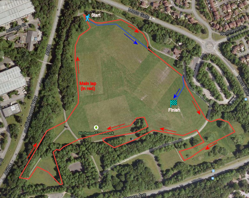
Birchwood Forest Park x/c Route
Cheshire Cross Country Championships
The course is entirely on grass and wooded trails, apart from where it crosses tarmac footpaths in several places. The bunkers are quite steep-sided and the underfoot conditions are often wet and muddy. Studded footwear or cross country spikes are usually best.
There are 3 different circuits with differing number of laps, depending on your category, as detailed HERE
Small Circuit

Medium Circuit

Large Circuit

North West Sunday Cross Country League route
The course below has been used for the NWSCCL race each year starting in 2008. The race distance in 2011 was 5.16 miles (8.3k) as measured by GPS.
The route shown on the map below is broadly accurate but there may be minor variations from year to year.
The race starts at the top of the grass bank (at the green marker arrow on the map). The route then goes alongside the football pitch and passes the finish (the red marker), followed by four complete laps.
The course is entirely on grass and wooded trails, apart from where it crosses tarmac footpaths in several places for just a few yards. The bunkers are quite steep-sided and the underfoot conditions are often wet and muddy. Studded footwear or cross country spikes are usually best.
Click here to see the course in Google Maps. There are minor variations from the map each year but it is mostly accurate.